X

Interested in the Harquail School of Earth Sciences?

Fill out this form and we will contact you with details about our programs!

Learn More!
?
Home >> Research >> Geophysics

Exploration Geophysics


Geophysics is the science of studying the Earth using the laws of physics.  One branch of geophysics known as exploration geophysics is used on a regional scale for discovery of the Earth's economic resources, such as mineral deposits and hydrocarbon reservoirs. The geophysics research at the Harquail School of Earth Sciences (HES) at Laurentian University is mainly focused on exploration geophysics for mineral prospecting.

Geophysics is the science of studying the Earth using the laws of physics. On a global scale, geophysicists study the phenomena such as earthquakes, magnetosphere, earth magnetic and gravity fields, planets, and etc. However, another branch of geophysics commonly known as exploration geophysics is used in regional scales for discovery and exploitation of the earth economical resources such as mineral deposits and hydrocarbon reservoirs. The common geophysical prospecting methods include the potential field (gravity and magnetic), electromagnetic (EM), geo-electric, induced polarization (IP), and seismic methods.

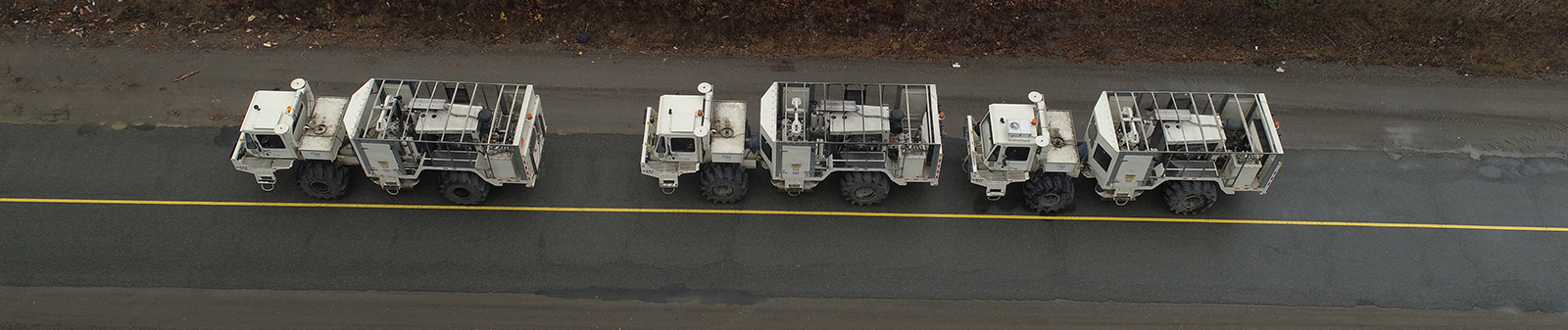
The potential field surveys capture the variations in the earth’s magnetic and gravity fields in order to identify the magnetic susceptibility and density anomalies beneath the surface, respectively. The EM and geo-electric methods map the electrical resistivity of the subsurface. In an IP survey, besides the resistivity measurement, electrical chargeability of the subsurface materials are determined as well. The goal of the seismic method is to gather, process and invert seismic wave fields to obtain an interpretable image of the subsurface. In the seismic method, a controlled pulse of energy provokes a disturbance in the surface of the earth that propagates into the subsurface and reflections on geological boundaries propagate back to the surface of the earth. This information is recorded by an array of receivers, saved, processed for SNR enhancement, and finally, used to produce an image of the subsurface. 

The geophysics research at the Harquail School of Earth Sciences (HES) at Laurentian University is mainly focused on exploration geophysics for mineral prospecting. It spans all aspects of the mentioned geophysical prospecting methods including data acquisition, processing, and interpretation. As part of Metal Earth project, a total of 1000 km long 2D seismic lines are gathered across the Canadian Shield in Quebec and Ontario Provinces in Fall 2017. The seismic data were collected with long offsets and various spatial sampling scenarios. This unique seismic dataset, combined with EM, potential field, and geoscience data collected along the same profiles, will be used to image shallow and deep structures of Canadian Shield for mineral exploration purposes.


Faculty & Research Scientists

  • Faculty

    Faculty

    • Mostafa Naghizadeh
      Mostafa Naghizadeh
      Assistant Professor, Seismic Geophysics

      Mostafa Naghizadeh joined us in September 2017 as an Assistant Professor of Geophysics with specialization in Exploration Seismology after five years of industry experience in seismic data processing. His research focuses on seismic data processing method, inversion problems, computational geophysics, and seismic applications for mineral exploration.

    • Richard S. Smith
      Richard Smith
      Professor, Industrial Research Chair Geophysics

      Richard Smith received a BSc and MSc from the University of Adelaide, Australia and an MSc and PhD from the University of Toronto. In 1989, he worked at Lamontagne Geophysics in Toronto (1989) where he helped develop methods for generating conductivity depth sections from airborne electromagnetic data. In 1990, Richard held an ARC post-doctoral fellowship at Macquarie University in Sydney (1990).

  • Post Doctoral Fellows

    Post Doctoral Fellows

    • Esmaeil Eshagi
      Esmaeil Eshagi
      Research Associate, Metal Earth

      Esmaeil has undertaken his PhD on multidisciplinary data compilation, potential field data processing and geophysical 3D modelling from CODES, University of Tasmania, Australia. He joined the Metal Earth team in 2017 working on compilation and processing of geophysical and petrophysical data in Archean Superior Craton.

  • PhD Candidates

    PhD Candidates

    • Francisca Maepa
      Francisca Maepa
      PhD candidate in Mineral Deposits and Precambrian Geology

      The purpose of my project is to find regions that are favorable for mineral deposits by employing data integration, machine learning techniques and, geo-statistics. This project will test these methods initially on the Swayze Greenstone Belt (SGB) and then attempt to apply the methods more generally to the Abitibi subprovince.

    • Tomas Naprstek
      PhD candidate Geophysics

      I graduated from the University of Waterloo with a B.Sc. Honours Physics degree in 2012, with my thesis focusing on the analysis of astrophysical data. In 2014 I completed my M.Sc. degree at Laurentian University, where my thesis investigated some of the physical relationships involved in the radio imaging method, primarily the effect of increasing dielectric permittivity on the resulting tomographic conductivity datasets.

    • Eric Roots
      Eric Roots
      PhD. Candidate

      I am studying magnetotelluric (MT) data and inversion with Dr. Richard Smith. I am interested in developing new methodologies which allow MT data to be inverted and interpreted alongside with co-located geological and geophysical data.

  • MSc Students

    MSc Students

    • Jacqueline Huggins
      Jacqueline Huggins
      MSc candidate Geology

      I have completed my BSc. at Laurentian University, completing an honours thesis on precious metal mineral distribution in footwall veins of the Morrison Deposit in Sudbury. I am currently completing my MSc. at Laurentian with a more geophysics based project to understand how much data can be extracted from physical properties measured from different rock samples.

    • Amir Maleki
      Amir Maleki
      MSc candidate Geology

      I am part of the Metal Earth project, and I have focused on applications of geophysical potential field data (i.e. gravity and magnetic) to distinguish the difference between endowed and less endowed regions, which will identify areas for future mineral exploration.

    • William McNeice
      William McNeice
      MSc candidate Geology

      Will Joined the Metal Earth team in 2017 as a Masters student. While his main focus is on physical rock properties, he often tries to be involved in as many components of the geophysical aspects of Metal Earth. Collaboration is his bread and butter when it comes to learning new things.

Additional Resources