Tue
19 JunMetal Earth Field Crew Overview
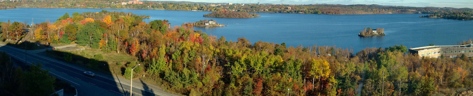
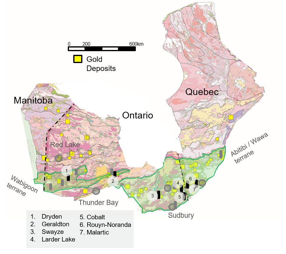
An overview of the research being conducted over the summer for Metal EarthIn order to reveal the fundamental geological processes that were responsible for the formation of mineral deposits in Superior Province, forty nine MSc, PhD students, research associates, and field assistants will be conducting research for the Metal Earth project across northern Ontario and Quebec. Here we highlight some of the objectives each team has over the summer. Research Locations:1. Stormy/Dryden, Ontario 2. Geraldton/Beardmore, Ontario 3. Swayze/Matheson, Ontario 4. Larder Lake, Ontario 5. Cobalt, Ontario 6. Rouyn Noranda, Quebec 7. Malartic, Quebec 8. Geophysics (Sudbury, Cobalt, Larder-Lake, Swayze, Matheson, Geraldton, and Dryden transects)
|
|
1. Stormy/Dryden
Ben Frieman (RA), Rebecca Montsion (PhD), Kendra Zammit (MSc), David Downie (MSc), Alec Graham (FA), Katharina Holt (FA), Austin Goncalves (FA)
Rebecca Montsion:
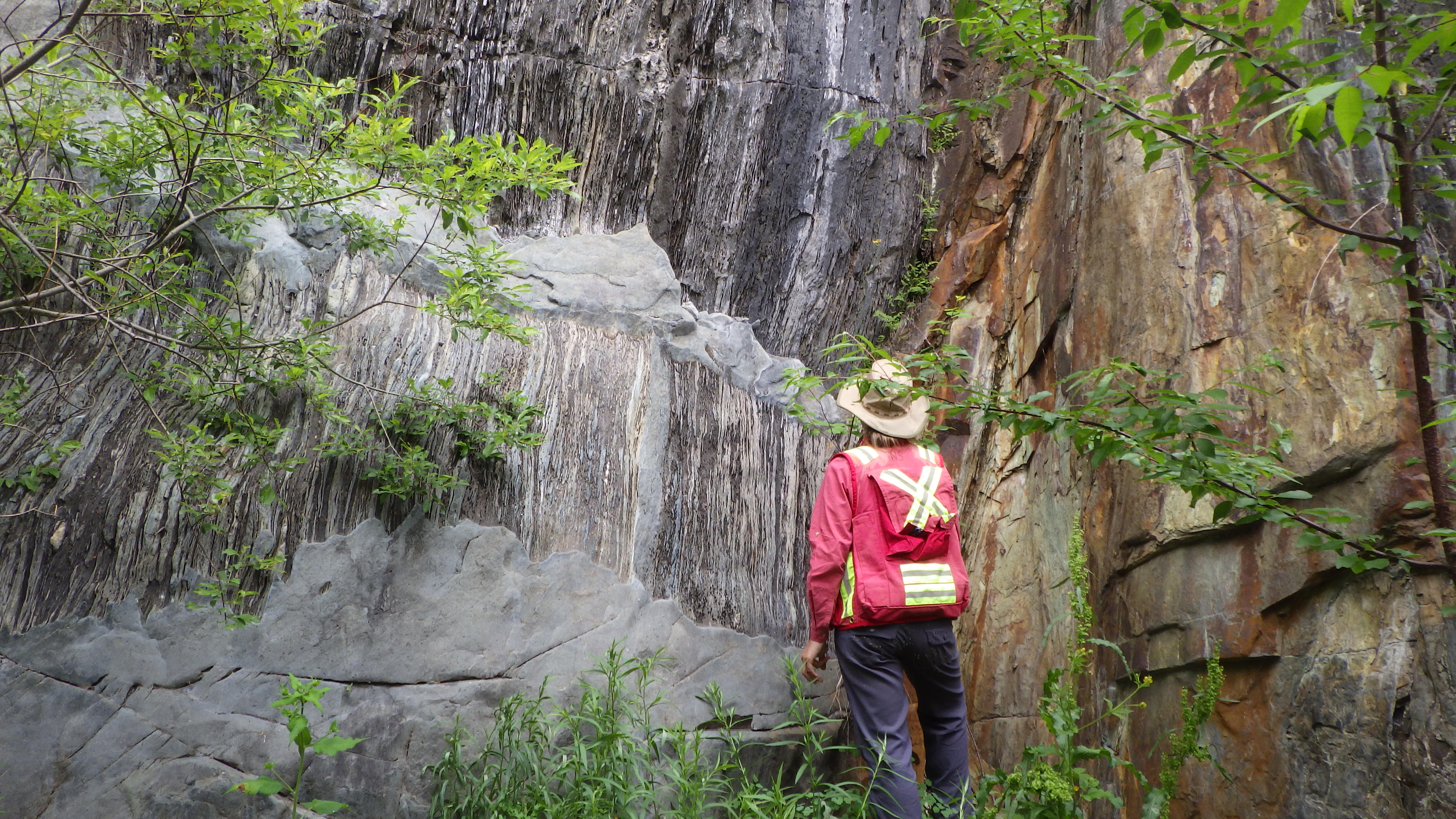
The project focuses on integration of geological, geochemical, and geophysical data in a 3D framework to explore the regional mineral system for greenstone belts in the Western Wabigoon Subprovince of the Superior Craton. The process of integration and the final model will provide a platform for investigation of uncertainty analysis techniques in 3D modelling and for generating prospectivity models in complex Archean terranes. This summer, a 2D map will be interpreted using existing geospatial databases and geophysics in a 140 x 100 km area of the Western Wabigoon Subprovince of the Superior Craton. Key areas related to the 3D model will be mapped in detail to further constrain the model. In addition to regional work, new data will be collected in a 2 km grid spacing for a 10 km buffer zone around Metal Earth’s Stormy / Dryden seismic transect. Data collected at these stations will include traditional geological observations as well as measurements using a gamma-ray spectrometer, magnetic susceptibility meter, and a portable x-ray fluorescence device. These data will support prospectivity modelling in later stages of this PhD project.
Kendra Zammit:
My project will seek to characterize the structural evolution of the Western Wabigoon Subprovince, an area which is relatively understudied in comparison to other Archean terranes in Ontario. I will also work towards determining the outcrop- to district- scale structural controls of the region's mineralization in meta-volcanic and meta-sedimentary rocks. My research is contributing to Metal Earth's initiative by helping to understand how structure can influence precious and base metal endowment in Archean greenstone belts, which are important hosts to many world-class gold deposits in Ontario.
2. Geraldton/Beardmore
Zsuzsanna Toth (RA), Keaton Strongman (PhD), Anna Haataja (FA), Jason Orloff (FA)
Work has begun on the Geraldton-Onaman transect that crosses from the Quetico metasedimentary subprovince to the granite-greenstone eastern Wabigoon subprovince through the Beardmore-Geraldton greenstone belt, ~240 km east of Thunder Bay, ON. This project aims to better understand the geological evolution of Geraldton-Onaman region that has similar geological characteristics to the Abitibi greenstone belt, yet has considerably less metal endowment.
Zsuzsanna Toth:
Zsuzsanna focuses largely on the structural evolution of the study area. Her research aims to review and establish the deformation history of different parts of the transect and the extent of the deformation events across major structures such as the Paint Lake Fault or the Quetico Fault that separate the Beardmore-Geraldton belt from the Onaman-Tashota greenstone belt and the Quetico subprovince respectively. Additionally, she is studying the contact relationships between unconformable geological units and how the various granitoid intrusions fit into the tectonic evolution of the area.
Keaton Strongman:
Keaton contributes to the transect research by establishing the volcanic stratigraphy, as well as the base and precious metal endowment of the Onaman-Tashota greenstone belt in order to improve our understanding of the volcanic evolution of the belt, and place the various mineralising systems into time-stratigraphic space. Both Keaton and Zsuzsanna are spending this field season conducting geological mapping at various scales and collecting samples for whole-rock and isotope geochemistry, and zircon geochronology.
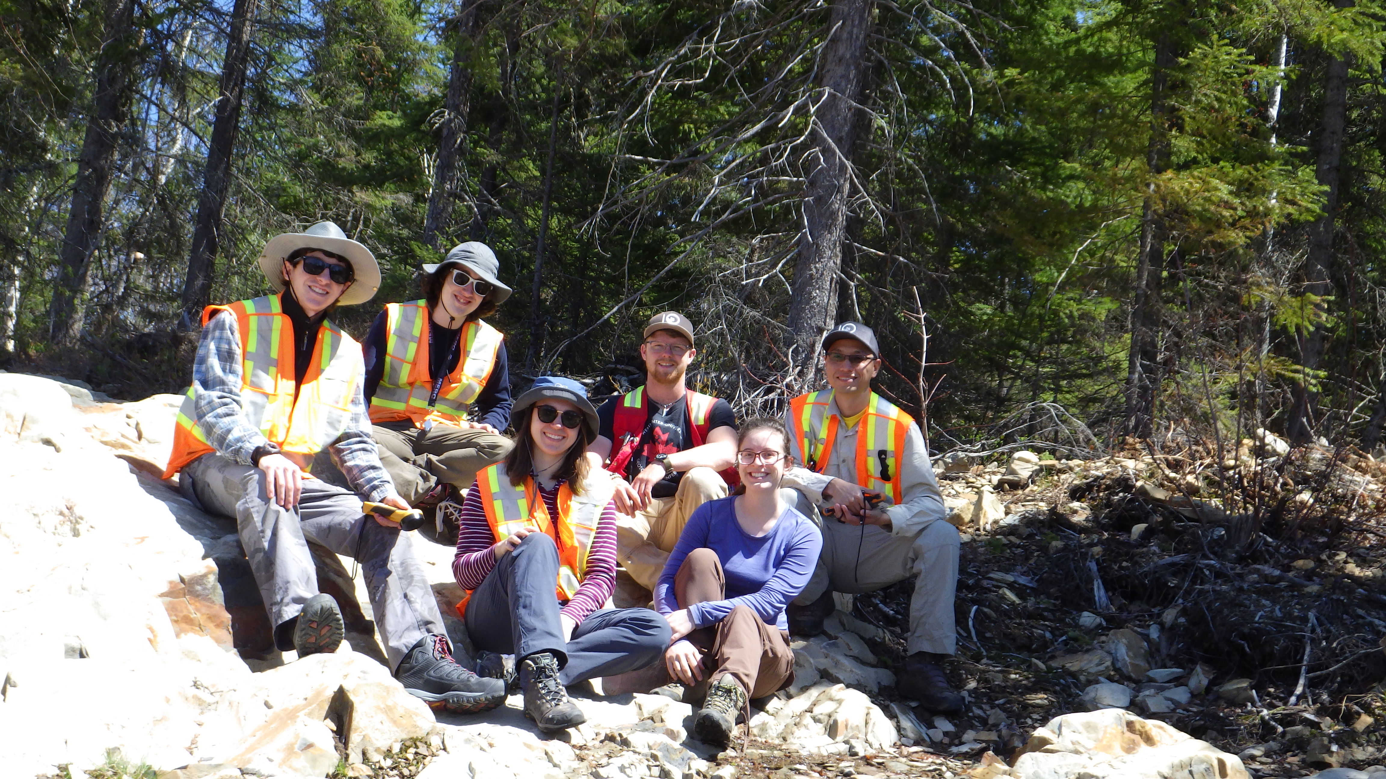
Caption: The Geraldton-Onaman team ready for take-off to visit the Marshall Lake area along the northern boundary of the Onaman-Tahsota greenstone belt. From left to right: Bruno Lafrance, Harold Gibson, Greg Stott, Jason Orloff, Anna Haataja, Keaton Strongman, Zsuzsanna Toth.
3. Swayze/Matheson
Rasmus Haugaard (RA), Daniel Meagher (FA)
The Swayze area comprises the western extent of the Abitibi Greenstone Belt (AGB). The Metal Earth mapping and transect research project through the Swayze area seeks to solve one of the main problems, which is: why the area historical has been less mineral endowed than the rest of the AGB further to the east? Such a fundamental question cannot be solved without a thorough understanding of the Swayze stratigraphy. Therefore, our goal is to map and interpret rock units and link these across the Swayze area and, if possible, to the rest of the AGB. Specifically, our work seeks to solve the large uncertainties in the nature and depositional ages of sedimentary basins in the south and in the north of the Swayze area (Figs. 1A and B). Understanding the timing and spatial distribution of these sedimentary basins are important as the majority of gold producing greenstone terranes in the AGB are closely associated with these sedimentary basins.
Furthermore, detailed field work is being carried out on a total of five banded iron formations around the Swayze area (Fig. 1C). These, alongside with the clastic sediment, represent important marker horizons between and within volcanic units and can help us establish a more coherent stratigraphy. We are also interesting in sedimentary interface zones and gaps in the volcanic activity as they may be crucial markers for potential syngenetic mineralization. The single most significant operation when carrying out field work is not only to find outcrops but to find the right outcrops. The Swayze area is general in deficit of exposed rocks. As a consequence, we collaborate closely with both mining and exploration companies as well as private consultants, which not only have multiple years of local geological knowledge, but also knows about strippings and outcrop locations around the Swayze area.
4. Larder Lake
Kate Rubingh (RA), Joshua Grattage (PhD), Nadia St-Jean (MSc), Sean Brace (MSc), Siobhán Keane (FA), Mac (John) Valliant (FA), Leslie Hunt (FA), Ayoub Mhina (FA)
Kate Rubingh:
A focused study on the characterisation of the albitite dykes to understand their relationship to mineralization along the LLCDZ; specifically, at Kerr Addison and the Cheminis deposit using drill core and field relationships, which will complement the work completed along the LLCDZ by the Masters student (Nadia St-Jean) and previous work on Cheminis by Lafrance (2015).
Nadia St-Jean:
The main objective of this Masters research project; which is located in close proximity to the ~11 million ounce Kerr-Addison gold deposit, is to examine the relationship between the younger Timiskaming metasedimentary rocks (ca. 2677-2670 Ma) and the older Larder Lake group metavolcanic rocks (ca. 2710-2704 Ma; equivalent to the Piché Group in Quebec). The contact between these two formations is defined by a major regional-scale structure, the Larder Lake Cadillac Deformation Zone (LLCDZ); which extends from Matachewan to Val’Dor, Quebec. The nature of this contact prior to deformation is still poorly understood, and questions remain as to whether the contact is structural or whether it could represent an unconformity. Understanding the nature of this contact is a main component of the Metal Earth contribution, and the results of this study have implications with respect to the overall nature of the LLCDZ and the origins of the Larder Lake group, as it occurs along this major structural trend.
 Caption: Visible gold in quartz veins in fuchsite altered ultramafic rocks from the Kerr - Addison Mine. (Photo from Nadia St-Jean, MSc).
Sean Brace:
Masters research project focused on the detailed characterization of a suite of mineralized mafic to felsic alkaline intrusions, that follow the trend of the Lincoln-Nipissing Shear Zone (LNSZ) through the north-central part of the Skead Township. This project will establish the petrogenesis of the suite of intrusions and the relative timing of gold mineralization with respect to the regional deformational framework.
The main contribution to Metal Earth from this project is a greater understanding of the nature of the LNSZ in order for comparison with the main LLCDZ. The LNSZ marks a break in structural framework and stratigraphy, where it juxtaposes the younger volcanic assemblages’ south of the shear zone, against the older Larder Lake Group volcanics to the north; which are unconformably overlain by younger clastic metasedimentary rocks of the Hearst assemblage (>2700 Ma). The shear zone is not well understood, due to the lack of surface expression, and its extent has been re-defined using airborne magnetic surveys conducted by metal earth.
Caption: Nadia St-Jean, MSc reviewing a shear zone in Larder Lake.
5. Cobalt
Shawna White (RA), Julian Johnson (FA), Spencer Pierce (FA)
During the 2018 field season, the Cobalt team has been focused on geologic mapping and sampling of Paleoproterozoic and Archean units exposed in the Cobalt area. In particular, the team is focused on determining the overall structure and stratigraphy of the Archean volcanic units and the overlying Paleoproterozoic sedimentary succession. These units are host to Ag-Co arsenide veins, which historically produced significant amounts of silver. Today, with the worlds growing demands for cobalt (used in lithium-ion batteries and superalloys), exploration has been renewed in the Cobalt region. By combining our field observations with the 2D seismic reflection data acquired by Metal Earth (2017), we hope to generate a 3D structural model which will aid in determining the structural controls on mineralization which will in turn create targets for future exploration.
6. Rouyn Noranda
Taus Joergensen (RA), Marina Schofield (PhD), Jonathan Sutton (MSc), Adrian Rhem (MSc), Andrew Bradley (FA), David Dickson (FA), Brandon Smith (FA), Aidan Paleczny (FA)
Taus Joergensen:
The second Metal Earth field season on the Rouyn-Noranda transect is underway. The crew consists of Marina Schofield (Ph.D.), Jonathan Sutton (M.Sc.), Adrien Rehm (M.Sc.), and Taus Jørgensen (RA) that are all returning for their second season. We are happy to welcome new undergraduate assistants Dave Dickson (Laurentian) and Aidan Paleczny (Queen's). It is also a pleasure to see the return of Brandon Smith (Laurentian) and Andrew Bradley (Laurentian) that are starting B.Sc. honors thesis projects on the Rouyn-Noranda transect on top of their field assistant duties. Fieldwork this year will focus on the metallogeny of the Powell Block located in the Rouyn-Noranda mineral district (M. Schofield), the hydrothermal system associated with the Fabie and Magusi VMS deposits (J. Sutton), the emplacement history of ultramafic- and mafic volcanic rocks in the Pontiac Subprovince (A. Rehm), and the petrogensis of an unusual mafic unit hosted in Timiskaming sedimentary rocks ~300 m south of the Lader Lake-Cadillac break (A. Bradley). Collection of geological observations along the entire Rouyn-Noranda transect (T. Jørgensen) is a continuous endeavor throughout the field season, which will help to constrain geophysical survey results (seismic) that have recently become available.
Marina Schofield:
PhD candidate Marina Schofield is undertaking a research project with Metal Earth focusing on the metallogeny of the Powell Block (PB), Rouyn Noranda. The PB is a 32 km2 wedge-shaped fault block, bound to the north by the Beauchastel fault and to the south by the Horne Creek Fault. The study area lies along the geophysical and geological transect of the Metal Earth project and, as such, this project will contribute to a better understanding of the geology of the transect. The PB is host to several styles of mineralization, which overlap spatially; orogenic style quartz-carbonate-Au vein mineralization, quartz-chalcopyrite-pyrite vein mineralization and the Quemont Au-rich volcanogenic massive sulfide (VMS) deposit. The quartz-chalcopyrite-pyrite vein mineralization is associated with an unusual spotted alteration texture, and the primary objective for this summer is to map out the spatial distribution of the spotted alteration and collect samples for mineral identification and geochemistry. In addition, particular emphasis this summer will be on identifying and characterizing all deformation events and generations of structures that affected the Powell Block, in order to fit the mineralization events into a stratigraphic-structural framework. The results of this study will have implications for Au-enrichment processes in VMS systems.
Jonathon Sutton:
My research focuses on reconstructing the hydrothermal system that is responsible for VMS mineralisation in the Duprat-Montbray formation and determine whether a nearby subvolcanic intrusion provided heat to the system. This summer I am mapping the volcanic stratigraphy and associated intrusions while also collecting samples that are systematically placed along two sample grids (a proximal 250m and regional 500m spaced grid). These samples will be analysed for whole-rock geochemistry and whole-rock 18O which will allow me to further document the elemental mass gains and losses as well as determine the temperature of the hydrothermal fluids that interacted with the host rocks in a given area. A correlation between the intrusion and the nearby VMS deposits can be provided in the case that zones of high temperature alteration are found around the intrusion and splay towards the deposits, identifying up flow zones. The deposits and intrusions I am working with are the same age as some of the more economically significant deposits in the Noranda camp. My research therefore compares my area to more prolific deposits and helps reconstruct the volcanic setting in Noranda. It could also serve as exploration vector to help find new VMS deposits.

Caption: Jonathan Sutton looking at all the outcrops he will be mapping this summer.
Andrew Bradley:
B.Sc. candidate Andrew Bradley is doing an Honours thesis with Metal Earth on the Rouyn-Noranda transect. Andrew is investigating the unusual occurrence of a mafic rock unit hosted in Timiskaming sedimentary rocks ~400 m south of the Larder Lake-Cadillac break (LLCB). The project includes bedrock mapping in order to constrain the extent of the unit and better understand the contact relationships with the surrounding sedimentary rocks. Samples of the mafic rock unit are collected for geochemistry (incl. extensive use of portable XRF), geochronology, and petrography to help determine its petrogenesis and mineral potential. The results from this study will have implications for the evolution of the Granada basin and potentially, regional scale pathways for mineralizing fluids.
7. Malartic
Xiaohui Zhou (RA), Brendon Samson (MSc), Danielle Shirriff (MSc), Luc Roy (FA), Samuel Battye (FA), Naomi Welt (FA)
The Superior Province is the largest exposed Archean craton in the world. It consists of generally east-striking subprovinces (e.g., Abitibi, Uchi) consisting of metavolcanic and granitoid rocks separated by subprovinces (e.g., Pontiac, English River) dominated by metasedimentary and gneissic rocks (Robert et al., 2005). Numerous world-class gold, volcanogenic massive sulphide and less-common magmatic nickel-copper deposits are spatially associated with east-striking subvertical crustal-scale fault zones along the subprovince boundaries (e.g., Cadillac–Larder Lake fault zone), or along the contact zones (Porcupine–Destor–Manneville fault zone) between metavolcanic and metasedimentary rocks within subprovinces (Robert and Poulsen, 1997; Hannington et al, 1999). This contribution is focused on roughly 100 km-long, highly metal-endowed Malartic transect area, which covers Neoarchean volcano-sedimentary and plutonic rocks in the southern Abitibi and Pontiac Subprovince (Figure 1). Major scientific topics include stratigraphic and structural setting of nickel (e.g. Cubric showing) and gold deposits (e.g., lode gold occurrences near Canadian Malaritc gold deposit), Provenance and age of Cadillac and Timiskaming Group sedimentary rocks, fault kinematics and timing of generally west-northwest–striking regional faults subparallel to Cadillac-Larder Lake break, and evolution of La Motte pluton and Northern and Southern Manneville faults. Multi-disciplinary (stratigraphy, structure, geochemistry, geochronology and geophysics) research on these topics will further our understanding of early Earth evolution and place formation of mineral deposits in complete and crustal scale geological processes.
Several contributions will be available to the public, including the entire transect map and cross section, which considers stratigraphic and structural data as well as seismic, magnetotelluric and aeromagnetic data. All these Metal Earth data will be well organized and made available to the public. Research articles originating from major scientific topics will be published in internationally recognized peer-reviewed journals. Two Master of Science theses will be completed with the Malartic transect project.
8. Geophysics
Graham Hill (RA), Eric Roots (PhD), Amir Maleki (MSc), William McNeice (MSc), Fabianno Della Justina (MSc), Brandon Hume (FA)
Geophysical prospecting methods such as reflection seismology, magnetotellurics (MT), and gravity, as well as geological observations, have been or will be acquired along selected transects perpendicular to the geological strikes in the Abitibi and Wabigon areas in order to differentiates highly mineralized zones from poorly mineralized ones in Precambrian Rocks in the Canadian Shield. The geophysical gravity crews are contributing to the Metal Earth via collecting and pre-processing of gravity data across seven transect such as the Sudbury, Cobalt, Larder-Lake, Swayze, Matheson, Geraldton, and Dryden transects during this summer field season of the project. The geophysical gravity crews will acquire approximately a total number of 1872 gravity observations.